CLIMBING K2
Select a point
Select a point
Climbing K2 - Base camp to Camp 4

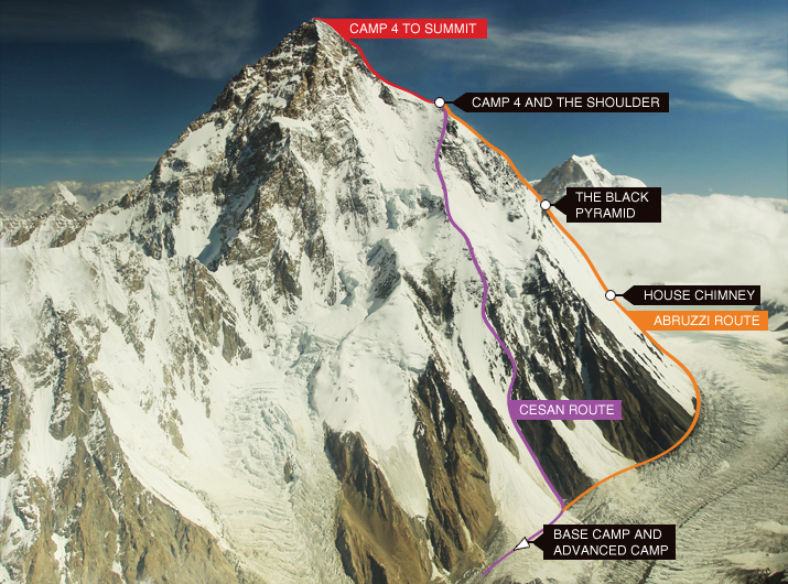
This spur, named after Italian climber Prince Luigi Amadeo, Duke of Abruzzi, is the lengthy route most commonly taken to reach the mountain’s summit of 8,612 meters. In 1909 Prince Luigi Amadeo led an Italian expedition to the base of K2 on the south Pakistani side of the mountain and made the first attempt at the Abruzzi Spur (formerly known as the Southeast Ridge), climbing to a height of 6250m. Beginning at an altitude of 5,400 meters, the Abruzzi spur is located on the south-side of K2, above the Base Camp on the Godwin- Austen Glacier and is also where Advanced Base Camp is usually situated. Its hazardous terrain of rock, snow and ice fields make it highly dangerous and requires technical rock climbing ability along the facets of "House’s Chimney" and the "Black Pyramid". From here, climbers must tackle treacherous slopes to finally reach the "Shoulder" and thence finally proceed to the summit.
Given the menacing characteristics of the Abruzzi Route, along with the customary hostile weather conditions, it is unsurprising that a majority of deaths occur along this well travelled ridge.
Also known as the South-Southeast Spur, this less common (but arguably safer) route was first travelled by Apinist Tomo Cesen in 1994. Sometimes referred to as the “Basque” or “Spanish” Route this 4000 meter trail follows a spur which is located on the right side of the south face of K2. From a 7800 meter shoulder it joins the Abruzzi Spur route, situated above Camp 3. Because this route relieves climbers from the burden of tackling the notorious “Black Pyramid” it is thought by some to be safer than the Abruzzi Route- providing general conditions are favourable. Technically however, it may be a little more demanding.
Base Camp is set-up on the Godwin-Austen Glacier, situated below the great south wall of K2. Climbers will later re-locate to the base of the Abruzzi Spur to form the Advanced Base Camp, 1 mile further up the glacier. The remaining route is divided by further camps, located at varying points along the mountain ascent.
Advancing from Camp 1 climbers will encounter a 500 meter track of snow and rock before reaching Camp 2 at 6,700 meters. Though generally windy and cold, this camp, usually set against a cliff on a shoulder, is at least safe from the risk of avalanche. Here also, climbers will find the” House Chimney”, a 30 meter rock wall split by a chimney and crack system which, if free-climbed, is rated 5.6. Named for the American climber who first climbed the wall in 1938, Bill House, it is today fixed with an array of old climbing ropes, making it fairly easy to tackle.
This dark, pyramid shaped 366 meter rock buttress within the Abruzzi Spur presents the most demanding climb of the entire route. Though not as technically complicated as the “House Chimney”, the terrain of mixed rock and ice, with near vertical cliffs usually covered with unstable snow slabs, make it a far more dangerous endeavour. Here, climbers will often store extra gear (tents, sleeping bags, stoves, food etc.). This is in case they are forced to descend for supplies should Camp 3 be swept away by an avalanche. Climbers will usually fix ropes up the” Black Pyramid” to facilitate climbing the structure and then rappelling down.
Ascending 342 meters from Camp 3 climbers, without fixed ropes, tackle steep slopes ranging from 25 to 40 degrees to reach the beginning of The Shoulder at 7,689 meters. The shoulder is a broad, low angle hump thickly covered by ice and snow. While there is no specific place to erect the final Camp 4, this placement will lie between 7,500 meters and 8,000 meters and is generally dictated by prevalent weather conditions. For many, the location of this last camp will be as high as possible, thus alleviating the elevation gain required for the final summit day.
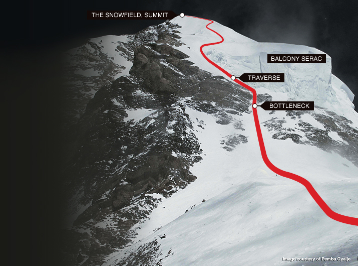
This final major obstacle, a narrow 91 meter passage (or couloir) known as the Bottleneck, is located only 400 meters below the summit. Climbers start out from a shoulder just below 8,000 meters, where usually the highest camp will be situated. The bottom end of the couloir drops to the south of the mountain and gradually steepens to 60 degrees just below the ice-field. It is not possible to climb up the ice-field, which rises vertically up tens of meters, but climbers must traverse leftwards at the bottom of the ice field by 100 meters until it is possible to pass. A thin fixed rope is often left on the traverse within The Bottleneck to allow climbers to safely ascend this section and to quickly descend out of danger. However, overhung by seracs (columns of ice) which form a 100 meter ice cliff to the east of the summit, climbers will still proceed dangerously close to the wall of these seracs. Indeed a collapse of one of these ice columns around 2001 contributed to the fact that no climbers summited the peak between 2002 and 2003. The height (8200 meters) and steepness (50-60 degrees) of this passage places climbers at their most vulnerable. In 2008 for example, a serac broke loose. Whilst projecting huge chunks of ice upon the climbers, the fixed ropes were all swept away thus isolating the stranded climbers above the couloir. It is possible to pass the Bottleneck by rock-climbing the cliffs to the left. However as the technical difficulty of this is quite acute, this slow- going alternative has only been done once, by Fritz Wiessner and Pasang Dawa Lama Sherpa in 1939.
The highly challenging, icy and steep climb up the Bottleneck leads to a delicate traverse. This traverse is a band of steep ice and snow situated at a gradient of between 50 and 70 degrees. Cutting directly and horizontally to the left for a distance of 61 meters the route rises diagonally for a further 122 meters onto a deeply covered but less steep slope of between 25 and 50 degrees. Above this section climbers will be overlooked by the serac whilst the tiny lines of the Godwin- Austen glacier lay 3,200 meters below. A thin fixed rope is often left on the traverse and in the Bottleneck to allow climbers to safely ascend this section and to quickly descend out of danger. To travel across this section teams will use karabiners on their belts to clip onto the rope and heave themselves along the face. The looping rope will be secured with ice screws at intervals along the way.
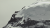
An enormous elevated mass of unstable glacial ice and snow overhanging the Bottleneck on the approach to K2’s summit
Following the long and icy traverse below the serac, the route escalates a further 91 meters up steep and wind- packed snow to reach the final summit ridge. This ice-coated plate is not a place to linger. Several climbers, including the great British alpinist Alison Hargreaves, and her five companions in 1995, were swept off this snow helmet by gale-force winds and lost into an icy oblivion. Now all that remains is a jagged snowy ridge. Climbers must ascend this ridge for a further 23 meters before finally conquering the 8, 612 meter summit of K2- the second highest point on the earth’s surface.

